
Make a donation
Gear up for your next adventure:
As an Amazon Associate, this site earns from qualifying purchases at no extra cost to you.
Aylesbury topographic map
Click on the map to display elevation.
Make a donation
Gear up for your next adventure:
As an Amazon Associate, this site earns from qualifying purchases at no extra cost to you.
Aylesbury
Aylesbury is immediately southeast of the upper River Thame that flows past Thame to Dorchester on Thames and is partly sited on the two northernmost outcrops of Portland (lime)stone in England bisected by a small stream, Bear Brook which gives a relatively prominent position in relation to the terrain of all near, lower, fields and suburbs, which have largely slowly permeable Oxford Clay and Kimmeridge Clay soils. Elevations range from 72.5m above mean sea level to 95m AOD in contiguous parts of the town, however nearest villages range from 85m-90m to the north or from 85m to 115m on a narrow ridge to the southwest at Stone and towards the Chilterns to the southeast (Weston Turville, Stoke Mandeville and North Lee).
Make a donation
Gear up for your next adventure:
As an Amazon Associate, this site earns from qualifying purchases at no extra cost to you.
About this map
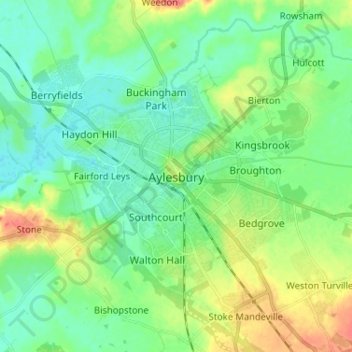
Name: Aylesbury topographic map, elevation, terrain.
Average elevation: 85 m
Minimum elevation: 69 m
Maximum elevation: 121 m
Make a donation
Gear up for your next adventure:
As an Amazon Associate, this site earns from qualifying purchases at no extra cost to you.