Geolocate

Arviat topographic map

Click on the map to display elevation.

About this map

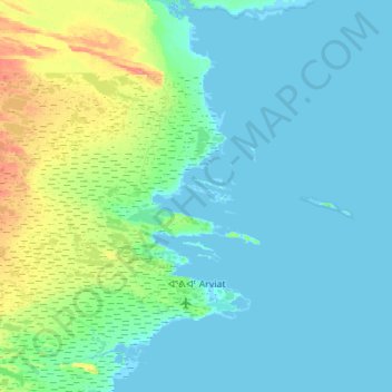
Name: Arviat topographic map, elevation, terrain.

Location: Arviat, Kivalliq Region, Nunavut, X0C 0E0, Canada (61.03360 -94.25011 61.29898 -93.96713)

Average elevation: 7 m

Minimum elevation: 0 m

Maximum elevation: 42 m

Kivalliq Region trails, hiking, mountain biking, running and outdoor activities

Other topographic maps

Click on a map to view its topography, its elevation and its terrain.

Nunalla

Canada > Nunavut > Kivalliq Region

Average elevation: 1 m

Whale Cove

Canada > Nunavut > Kivalliq Region

Average elevation: 5 m

Baker Lake

Canada > Nunavut > Kivalliq Region

Average elevation: 50 m

Gear up for your next adventure:

🧦Hiking Socks - Moisture-wicking and comfortable socks for long hikes
🥾Lightweight Hiking Boots - Boots for comfort and mobility on long hikes
🚲Heavy Duty Bike Lock - Secure your bike at the trailhead or during stops
🧴First Aid Kit - Essential first aid supplies for outdoor emergencies
🥾Light Trekking Boots - Supportive boots for multi-day treks

As an Amazon Associate, this site earns from qualifying purchases at no extra cost to you.