Geolocate

Holmo topographic map

Interactive map

Click on the map to display elevation.

About this map

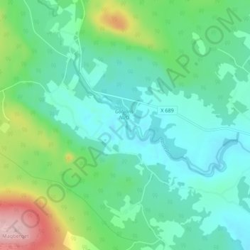
Name: Holmo topographic map, elevation, terrain.

Location: Holmo, Bollnäs kommun, Gävleborg County, Sweden (61.37854 16.31136 61.41854 16.35136)

Average elevation: 121 m

Minimum elevation: 75 m

Maximum elevation: 264 m

Other topographic maps

Click on a map to view its topography, its elevation and its terrain.

Gran

Sweden > Gävleborg County > Gnarp District

Average elevation: 0 m

Disan

Sweden > Gävleborg County

Average elevation: 43 m

Söderhamns kommun

Sweden > Gävleborg County

Average elevation: 67 m

Hudiksvalls kommun

Sweden > Gävleborg County

Average elevation: 95 m

Gnarp District

Sweden > Gävleborg County

Average elevation: 32 m

Gävle kommun

Sweden > Gävleborg County

Average elevation: 61 m

Ovanåkers kommun

Sweden > Gävleborg County

Average elevation: 269 m

Ljusdals kommun

Sweden > Gävleborg County

Average elevation: 317 m

Gävle

Sweden > Gävleborg County

Average elevation: 27 m

Hofors kommun

Sweden > Gävleborg County

Average elevation: 147 m