
Make a donation
Gear up for your next adventure:
As an Amazon Associate, this site earns from qualifying purchases at no extra cost to you.
Lentini topographic map
Click on the map to display elevation.
Make a donation
Gear up for your next adventure:
As an Amazon Associate, this site earns from qualifying purchases at no extra cost to you.
Lentini
Lentini is a municipality of 215.84 km² located 52 km northwest of the provincial capital, Syracuse. It is situated at an elevation of 53 meters above sea level on the first hill slopes at the southern edge of the Plain of Catania.
Make a donation
Gear up for your next adventure:
As an Amazon Associate, this site earns from qualifying purchases at no extra cost to you.
About this map
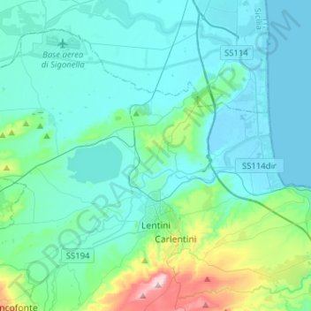
Name: Lentini topographic map, elevation, terrain.
Location: Lentini, Siracusa, Sicily, 96016, Italy (37.24796 14.77834 37.41288 15.03319)
Average elevation: 69 m
Minimum elevation: -2 m
Maximum elevation: 480 m
Make a donation
Gear up for your next adventure:
As an Amazon Associate, this site earns from qualifying purchases at no extra cost to you.
Other topographic maps
Click on a map to view its topography, its elevation and its terrain.