Geolocate

Fairstead topographic map

Click on the map to display elevation.

About this map

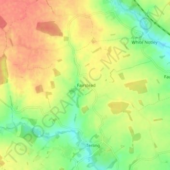
Name: Fairstead topographic map, elevation, terrain.

Location: Fairstead, Braintree, Essex, East of England, England, United Kingdom (51.80640 0.52251 51.83797 0.59721)

Average elevation: 54 m

Minimum elevation: 25 m

Maximum elevation: 81 m

Other topographic maps

Click on a map to view its topography, its elevation and its terrain.

Great Saling

United Kingdom > England > Essex > Braintree

Average elevation: 80 m

Baythorne End

United Kingdom > England > Essex > Braintree

Average elevation: 72 m

Rivenhall End

United Kingdom > England > Essex > Braintree

Average elevation: 33 m

Blackmore End

United Kingdom > England > Essex > Braintree

Average elevation: 82 m

Pattiswick

United Kingdom > England > Essex > Braintree

Average elevation: 57 m

Beazley End

United Kingdom > England > Essex > Braintree

Average elevation: 75 m

Bocking

United Kingdom > England > Essex > Braintree

Average elevation: 63 m

Cornish Hall End

United Kingdom > England > Essex > Braintree

Average elevation: 97 m

Gear up for your next adventure:

🧥Waterproof Pants - Keep dry during rainy hiking conditions
🛌Down Sleeping Bag - Superior warmth-to-weight ratio for cold nights
🧭GPS Handheld Device - Reliable GPS navigation for outdoor adventures
🧦Hiking Socks - Moisture-wicking and comfortable socks for long hikes
🧴Waterproofing Spray - Restore the DWR coating on jackets and tents

As an Amazon Associate, this site earns from qualifying purchases at no extra cost to you.