Geolocate

Pinola topographic map

Click on the map to display elevation.

About this map

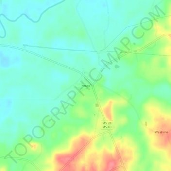
Name: Pinola topographic map, elevation, terrain.

Location: Pinola, Simpson County, Mississippi, United States (31.85710 -89.98203 31.89710 -89.94203)

Average elevation: 96 m

Minimum elevation: 72 m

Maximum elevation: 143 m

Other topographic maps

Click on a map to view its topography, its elevation and its terrain.

Mendenhall

United States > Mississippi > Simpson County

Average elevation: 109 m

Magee

United States > Mississippi > Simpson County

Average elevation: 132 m

Gear up for your next adventure:

💡LED Camping Lantern - Illuminate your campsite with long-lasting lanterns
Lightweight Camping Tent - Portable shelter optimized for Canadian backcountry camping
🧦Hiking Liner Socks - Thin base layer to prevent friction and blisters
🔦LED Headlamp - Hands-free lighting for early morning starts or late finishes
🥾Approach Boots - Comfortable boots for hiking and climbing approaches

As an Amazon Associate, this site earns from qualifying purchases at no extra cost to you.