
Make a donation
Gear up for your next adventure:
As an Amazon Associate, this site earns from qualifying purchases at no extra cost to you.
Bärenstein topographic map
Click on the map to display elevation.
Make a donation
Gear up for your next adventure:
As an Amazon Associate, this site earns from qualifying purchases at no extra cost to you.
About this map
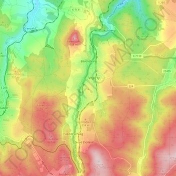
Name: Bärenstein topographic map, elevation, terrain.
Location: Bärenstein, Erzgebirgskreis, Sachsen, Deutschland (50.45161 13.00959 50.52408 13.04610)
Average elevation: 771 m
Minimum elevation: 607 m
Maximum elevation: 929 m
Make a donation
Gear up for your next adventure:
As an Amazon Associate, this site earns from qualifying purchases at no extra cost to you.
Other topographic maps
Click on a map to view its topography, its elevation and its terrain.
Satzung
Deutschland > Sachsen > Erzgebirgskreis > Marienberg
1910 wurde Satzung anerkannter Höhenluftkurort, 1915 erhielt er Anschluss an das Elektrizitätsnetz. In der Folge wurden 1927 eine Zufahrt zum Hirtstein und eine Bergbaude errichtet. Einen Rathausneubau erhielt der Ort 1939. Im März 1944 war der Ort durch heftige Schneefälle mit Verwehungen von der…
Average elevation: 829 m
Make a donation
Gear up for your next adventure:
As an Amazon Associate, this site earns from qualifying purchases at no extra cost to you.
Oberschmiedeberg
Deutschland > Sachsen > Erzgebirgskreis > Jöhstadt > Steinbach
Average elevation: 635 m