
Make a donation
Gear up for your next adventure:
As an Amazon Associate, this site earns from qualifying purchases at no extra cost to you.
Bunia topographic map
Click on the map to display elevation.
Make a donation
Gear up for your next adventure:
As an Amazon Associate, this site earns from qualifying purchases at no extra cost to you.
Bunia
It lies at an elevation of 1,275 metres or 4,180 feet on a plateau about 30 kilometres or 19 miles west of Lake Albert in the Albertine Rift, and about 25 kilometres or 16 miles east of the Ituri Rainforest.
Make a donation
Gear up for your next adventure:
As an Amazon Associate, this site earns from qualifying purchases at no extra cost to you.
About this map
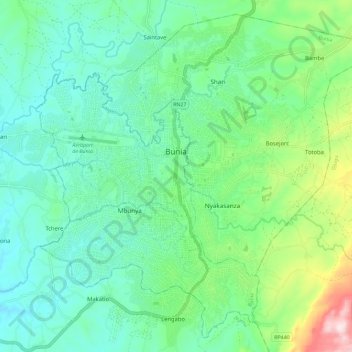
Name: Bunia topographic map, elevation, terrain.
Location: Bunia, Ituri, Democratic Republic of the Congo (1.50098 30.20198 1.60705 30.31717)
Average elevation: 1,273 m
Minimum elevation: 1,156 m
Maximum elevation: 1,636 m
Make a donation
Gear up for your next adventure:
As an Amazon Associate, this site earns from qualifying purchases at no extra cost to you.
Other topographic maps
Click on a map to view its topography, its elevation and its terrain.
Make a donation
Gear up for your next adventure:
As an Amazon Associate, this site earns from qualifying purchases at no extra cost to you.