
Thank you for supporting this site ❤️
Make a donation
Make a donation
Gear up for your next adventure:
As an Amazon Associate, this site earns from qualifying purchases at no extra cost to you.
Longavi topographic map
Click on the map to display elevation.
Thank you for supporting this site ❤️
Make a donation
Make a donation
Gear up for your next adventure:
As an Amazon Associate, this site earns from qualifying purchases at no extra cost to you.
About this map
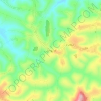
Name: Longavi topographic map, elevation, terrain.
Location: Longavi, Djugu, Ituri, Democratic Republic of the Congo (2.06689 30.79261 2.10689 30.83261)
Average elevation: 2,005 m
Minimum elevation: 1,909 m
Maximum elevation: 2,150 m
Thank you for supporting this site ❤️
Make a donation
Make a donation
Gear up for your next adventure:
As an Amazon Associate, this site earns from qualifying purchases at no extra cost to you.