
Make a donation
Gear up for your next adventure:
As an Amazon Associate, this site earns from qualifying purchases at no extra cost to you.
Hulu Selangor topographic map
Click on the map to display elevation.
Make a donation
Gear up for your next adventure:
As an Amazon Associate, this site earns from qualifying purchases at no extra cost to you.
About this map
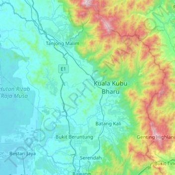
Name: Hulu Selangor topographic map, elevation, terrain.
Location: Hulu Selangor, Selangor, Malaysia (3.32134 101.31959 3.80421 101.81507)
Average elevation: 345 m
Minimum elevation: 2 m
Maximum elevation: 1,903 m
Make a donation
Gear up for your next adventure:
As an Amazon Associate, this site earns from qualifying purchases at no extra cost to you.
Other topographic maps
Click on a map to view its topography, its elevation and its terrain.
Make a donation
Gear up for your next adventure:
As an Amazon Associate, this site earns from qualifying purchases at no extra cost to you.
Sungai Air Hitam
Malaysia > Selangor > Kajang Municipal Council > Bandar Baru Bangi
Average elevation: 46 m
Kampung Baru Semenyih
Malaysia > Selangor > Kajang Municipal Council > Semenyih > Kampung Baru Semenyih
Average elevation: 48 m
Make a donation
Gear up for your next adventure:
As an Amazon Associate, this site earns from qualifying purchases at no extra cost to you.