
Batu Arang topographic map
Click on the map to display elevation.
About this map
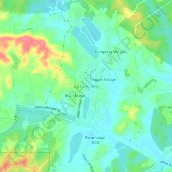
Name: Batu Arang topographic map, elevation, terrain.
Location: Batu Arang, Gombak, Selangor, 48100, Malaysia (3.29491 101.45103 3.33491 101.49103)
Average elevation: 43 m
Minimum elevation: 18 m
Maximum elevation: 104 m
Other topographic maps
Click on a map to view its topography, its elevation and its terrain.
Sungai Air Hitam
Malaysia > Selangor > Kajang Municipal Council > Bandar Baru Bangi
Average elevation: 46 m
Kampung Baru Semenyih
Malaysia > Selangor > Kajang Municipal Council > Semenyih > Kampung Baru Semenyih
Average elevation: 48 m