Geolocate

Ephrata topographic map

Interactive map

Click on the map to display elevation.

About this map

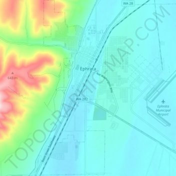
Name: Ephrata topographic map, elevation, terrain.

Location: Ephrata, Grant County, Washington, 98823, United States (47.28070 -119.58373 47.34123 -119.49620)

Average elevation: 434 m

Minimum elevation: 373 m

Maximum elevation: 685 m

The settlement of Ephrata is quite recent. There was no known settlement until 1886, just three years before Washington gained statehood. The horse rancher Frank Beezley was the first to settle near the natural springs, thus the area was known as Beezley Springs. As the climate and topography were not promising to settlement, the entire region remained sparsely populated until several federal congressional actions, including the Northern Pacific Land Grant Act, the Homestead Act, and Desert Claims Act, encouraged the settlement of this semi-arid desert-like area. Originally, Douglas County spread over the entire territory of the Big Bend of the Columbia River. In 1909, the Washington State legislature divided it, creating Grant County. When the time came to present arguments to the state legislature regarding which town should be the county seat, someone apparently intentionally intoxicated the representative of a rival community, and Ephrata was chosen.

Wikipedia (CC-BY-SA 3.0)

Other topographic maps

Click on a map to view its topography, its elevation and its terrain.

Moses Lake

United States > Washington > Grant County

Moses Lake, Grant County, Washington, 98837, United States

Average elevation: 350 m

Coulee City

United States > Washington > Grant County

Coulee City, Grant County, Washington, United States

Average elevation: 485 m

Royal City

United States > Washington > Grant County

Royal City, Grant County, Washington, 99357, United States

Average elevation: 313 m

Marlin

United States > Washington > Grant County

Marlin, Grant County, Washington, United States

Average elevation: 430 m

Desert Aire

United States > Washington > Grant County

Desert Aire, Grant County, Washington, United States

Average elevation: 177 m

George

United States > Washington > Grant County

George, Grant County, Washington, 98824, United States

Average elevation: 372 m

Schwana

United States > Washington > Grant County

Schwana, Grant County, Washington, 99321, United States

Average elevation: 215 m

Hartline

United States > Washington > Grant County

Hartline, Grant County, Washington, United States

Average elevation: 586 m

Stratford

United States > Washington > Grant County

Stratford, Grant County, Washington, 98853, United States

Average elevation: 428 m

Wilson Creek

United States > Washington > Grant County

Wilson Creek, Grant County, Washington, United States

Average elevation: 415 m

Grand Coulee

United States > Washington > Grant County

Grand Coulee, Grant County, Washington, 99133, United States

Average elevation: 502 m

Warden

United States > Washington > Grant County

Warden, Grant County, Washington, 98857, United States

Average elevation: 393 m

McDonald

United States > Washington > Grant County > McDonald

McDonald, Grant County, Washington, United States

Average elevation: 356 m

Moses Lake

United States > Washington > Grant County > Moses Lake > Moses Lake

Moses Lake, Grant County, Washington, 98837, United States

Average elevation: 342 m

Beverly

United States > Washington > Grant County

Beverly, Grant County, Washington, 99321, United States

Average elevation: 194 m

Mattawa

United States > Washington > Grant County

Mattawa, Grant County, Washington, United States

Average elevation: 223 m

Quincy

United States > Washington > Grant County

Quincy, Grant County, Washington, United States

Average elevation: 400 m

Electric City

United States > Washington > Grant County

Electric City, Grant County, Washington, 99123, United States

Average elevation: 506 m

Soap Lake

United States > Washington > Grant County

Soap Lake, Grant County, Washington, 98851, United States

Average elevation: 352 m