Geolocate

Cwmtillery topographic map

Click on the map to display elevation.

About this map
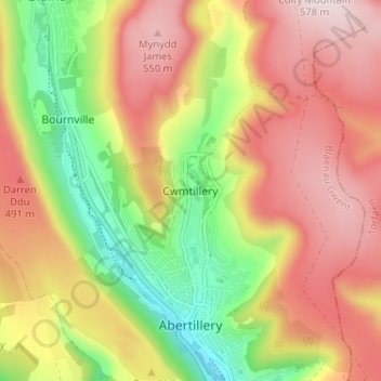
Name: Cwmtillery topographic map, elevation, terrain.

Location: Cwmtillery, Blaenau Gwent, Wales, NP13 1RB, United Kingdom (51.72406 -3.15602 51.76406 -3.11602)

Average elevation: 395 m

Minimum elevation: 188 m

Maximum elevation: 574 m

Other topographic maps

Click on a map to view its topography, its elevation and its terrain.

Blaina

United Kingdom > Wales > Blaenau Gwent > Cwmcelyn

Average elevation: 397 m

Cardiff Pond

United Kingdom > Wales > Blaenau Gwent > Ebbw Vale

Average elevation: 349 m

Blaina

United Kingdom > Wales > Blaenau Gwent > Cwmcelyn

Average elevation: 397 m

Gear up for your next adventure:

🌡️Emergency Mylar Blankets - Compact thermal protection for unexpected nights outdoors
🧥Ultralight Puffy Jacket - Maximum warmth that packs down to the size of an orange
🚑Survival Whistle - Signal for help across long distances in mountains
🚲Heavy Duty Bike Lock - Secure your bike at the trailhead or during stops
🛶Kayak Dry Bag - Waterproof storage for kayaking adventures

As an Amazon Associate, this site earns from qualifying purchases at no extra cost to you.