Geolocate

Foggia topographic map

Click on the map to display elevation.

About this map

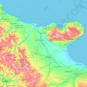
Name: Foggia topographic map, elevation, terrain.

Location: Foggia, Apulia, Italy (41.05571 14.93419 42.22648 16.20143)

Average elevation: 211 m

Minimum elevation: -5 m

Maximum elevation: 1,133 m

Other topographic maps

Click on a map to view its topography, its elevation and its terrain.

Segezia

Italy > Apulia > Foggia > Foggia

Average elevation: 142 m

Le Marine

Italy > Apulia > Bari > Noicattaro > Le Marine

Average elevation: 26 m

Gear up for your next adventure:

🧰Survival Kit - Essential gear for emergencies in the wilderness
🔦LED Headlamp - Hands-free lighting for early morning starts or late finishes
🧥Ultralight Puffy Jacket - Maximum warmth that packs down to the size of an orange
🧢Beanie Hat - Keep your head warm in cold weather
🧭Orienteering Kit - Tools for map reading and navigation in the wild

As an Amazon Associate, this site earns from qualifying purchases at no extra cost to you.