Geolocate

Charlottenberg topographic map

Click on the map to display elevation.

About this map

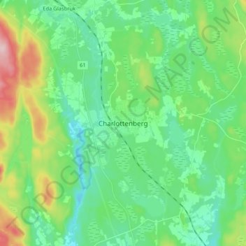
Name: Charlottenberg topographic map, elevation, terrain.

Location: Charlottenberg, Eda kommun, Värmland County, 673 22, Sweden (59.84396 12.26492 59.92396 12.34492)

Average elevation: 143 m

Minimum elevation: 89 m

Maximum elevation: 293 m

Other topographic maps

Click on a map to view its topography, its elevation and its terrain.

Sunne kommun

Sweden > Värmland County

Average elevation: 194 m

Hammarö kommun

Sweden > Värmland County

Average elevation: 45 m

Hammarö kommun

Sweden > Värmland County

Average elevation: 45 m

Hagfors kommun

Sweden > Värmland County

Average elevation: 257 m

Kils kommun

Sweden > Värmland County

Average elevation: 104 m

Torsby kommun

Sweden > Värmland County

Average elevation: 356 m

Pottern

Sweden > Värmland County

Average elevation: 145 m

Säffle kommun

Sweden > Värmland County

Average elevation: 89 m

Karlstads kommun

Sweden > Värmland County

Average elevation: 109 m

Filipstads kommun

Sweden > Värmland County

Average elevation: 241 m

Storfors kommun

Sweden > Värmland County

Average elevation: 158 m

Gear up for your next adventure:

🚲Heavy Duty Bike Lock - Secure your bike at the trailhead or during stops
🧶550 Survival Paracord - Versatile utility cord for emergency repairs and rigging
🧴Insect Repellent - Protect yourself from bugs during outdoor adventures
🧣Merino Neck Gaiter - Protects against wind, sun, and cold at high altitudes
🧭GPS Outdoor Watch - Smart watch for navigation and fitness tracking in nature

As an Amazon Associate, this site earns from qualifying purchases at no extra cost to you.