
Make a donation
Gear up for your next adventure:
As an Amazon Associate, this site earns from qualifying purchases at no extra cost to you.
Ziama Mansouriah topographic map
Click on the map to display elevation.
Make a donation
Gear up for your next adventure:
As an Amazon Associate, this site earns from qualifying purchases at no extra cost to you.
About this map
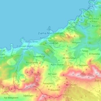
Name: Ziama Mansouriah topographic map, elevation, terrain.
Location: Ziama Mansouriah, Daïra Ziama Mansouriah, Jijel, Algérie (36.58939 5.41982 36.71197 5.57574)
Average elevation: 372 m
Minimum elevation: -1 m
Maximum elevation: 1,431 m
Make a donation
Gear up for your next adventure:
As an Amazon Associate, this site earns from qualifying purchases at no extra cost to you.
Other topographic maps
Click on a map to view its topography, its elevation and its terrain.
Plage Rouge
Algérie > Jijel > Daïra Ziama Mansouriah > Ziama Mansouriah > Taâzibt > Boulesbiâ
Average elevation: 57 m
Adjerrar
Algérie > Jijel > Daïra Ziama Mansouriah > Ziama Mansouriah > Aït Saad > Ikmache
Average elevation: 616 m
Ighzer n Tourtout
Algérie > Jijel > Daïra Ziama Mansouriah > Ziama Mansouriah > Iâayaden > Anza Makhlouf
Average elevation: 777 m
Make a donation
Gear up for your next adventure:
As an Amazon Associate, this site earns from qualifying purchases at no extra cost to you.
Mkhassel
Algérie > Jijel > Daïra Ziama Mansouriah > Ziama Mansouriah > Bir Ghzala
Average elevation: 860 m
Make a donation
Gear up for your next adventure:
As an Amazon Associate, this site earns from qualifying purchases at no extra cost to you.
Boumraw
Algérie > Jijel > Daïra Ziama Mansouriah > Ziama Mansouriah > Aït Achour
Average elevation: 399 m