
Thank you for supporting this site ❤️
Make a donation
Make a donation
Gear up for your next adventure:
As an Amazon Associate, this site earns from qualifying purchases at no extra cost to you.
El Houita topographic map
Click on the map to display elevation.
Thank you for supporting this site ❤️
Make a donation
Make a donation
Gear up for your next adventure:
As an Amazon Associate, this site earns from qualifying purchases at no extra cost to you.
About this map
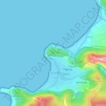
Name: El Houita topographic map, elevation, terrain.
Average elevation: 35 m
Minimum elevation: 0 m
Maximum elevation: 286 m
Thank you for supporting this site ❤️
Make a donation
Make a donation
Gear up for your next adventure:
As an Amazon Associate, this site earns from qualifying purchases at no extra cost to you.
Other topographic maps
Click on a map to view its topography, its elevation and its terrain.
Plage Rouge
Algérie > Jijel > Daïra Ziama Mansouriah > Ziama Mansouriah > Taâzibt > Boulesbiâ
Average elevation: 57 m
Ighzer n Tourtout
Algérie > Jijel > Daïra Ziama Mansouriah > Ziama Mansouriah > Iâayaden > Anza Makhlouf
Average elevation: 777 m