
Bușteni topographic map
Interactive map
Click on the map to display elevation.
About this map
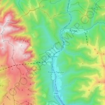
Name: Bușteni topographic map, elevation, terrain.
Location: Bușteni, Prahova, Roumanie (45.36783 25.45256 45.47040 25.62365)
Average elevation: 1,419 m
Minimum elevation: 807 m
Maximum elevation: 2,500 m
La ville a été le théâtre de nombreux combats en 1916 entre l'armée roumaine et l'armée austro-hongroise. Après la Première Guerre mondiale, une grande croix métallique (Crucea Eroilor Neamului) de 25 m de haut a été construite à 2 291 m d'altitude, près du sommet du Mont Caraiman, qui domine la ville, en hommage aux nombreux soldats roumains tombés dans les parages.
Other topographic maps
Click on a map to view its topography, its elevation and its terrain.
Măneciu-Pământeni
Măneciu-Pământeni, Măneciu, Prahova, 107362, Roumanie
Average elevation: 535 m