Geolocate

Măneciu topographic map

Interactive map

Click on the map to display elevation.

About this map

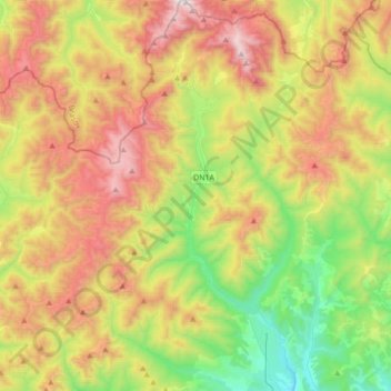
Name: Măneciu topographic map, elevation, terrain.

Location: Măneciu, Prahova, Roumanie (45.28139 25.84894 45.52257 26.02903)

Average elevation: 1,083 m

Minimum elevation: 459 m

Maximum elevation: 1,933 m

Other topographic maps

Click on a map to view its topography, its elevation and its terrain.

Starchiojd

Roumanie > Prahova

Starchiojd, Prahova, Roumanie

Average elevation: 762 m

Măneciu-Pământeni

Roumanie > Prahova

Măneciu-Pământeni, Măneciu, Prahova, 107362, Roumanie

Average elevation: 535 m

Ploiești

Roumanie > Prahova

Ploiești, Prahova, Roumanie

Average elevation: 158 m

Sinaia

Roumanie > Prahova

Sinaia, Prahova, 106100, Roumanie

Average elevation: 1,249 m

Matița

Roumanie > Prahova > Matița

Matița, Prahova, 107398, Roumanie

Average elevation: 290 m

Plopeni

Roumanie > Prahova > Plopeni

Plopeni, Prahova, Roumanie

Average elevation: 261 m

Bușteni

Roumanie > Prahova

Bușteni, Prahova, Roumanie

Average elevation: 1,419 m

Ciorani

Roumanie > Prahova

Ciorani, Prahova, Roumanie

Average elevation: 75 m