
Kersey topographic map
Click on the map to display elevation.
About this map
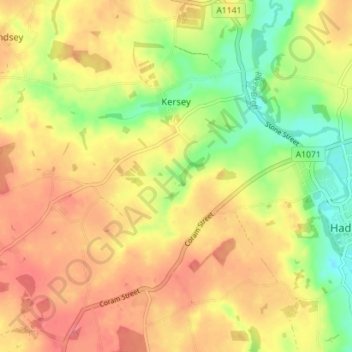
Name: Kersey topographic map, elevation, terrain.
Location: Kersey, Babergh, Suffolk, England, United Kingdom (52.03117 0.86553 52.06996 0.93595)
Average elevation: 51 m
Minimum elevation: 15 m
Maximum elevation: 77 m
Other topographic maps
Click on a map to view its topography, its elevation and its terrain.
Constable 'The Haywain' viewing point
United Kingdom > England > Suffolk > Babergh > East Bergholt > Flatford
Average elevation: 15 m
Mill Green
United Kingdom > England > Suffolk > Babergh > Edwardstone > Mill Green
Average elevation: 59 m
Flatford
United Kingdom > England > Suffolk > Babergh > East Bergholt > Flatford
Average elevation: 22 m
Long Melford-Bury St Edmunds branch line
United Kingdom > England > Suffolk > Babergh > Lavenham
Average elevation: 70 m