
Mountain Pass topographic map
Click on the map to display elevation.
About this map
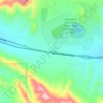
Name: Mountain Pass topographic map, elevation, terrain.
Average elevation: 1,506 m
Minimum elevation: 1,382 m
Maximum elevation: 1,819 m
Other topographic maps
Click on a map to view its topography, its elevation and its terrain.
Big Bear Lake
United States > California > San Bernardino County > Big Bear Lake
At a surface elevation of 6,743 ft (2,055 m) above sea level, it has an east-west length of approximately seven miles (11 km) and is approximately 2.5 miles (4.0 km) at its widest measurement, though the lake's width mostly averages a little more than 1⁄2 mi (0.8 km). These approximations are based on the…
Average elevation: 2,209 m
Yucca Valley
United States > California > San Bernardino County
Yucca Valley lies in the middle of the Morongo Basin at a base elevation of 3,300 feet. Joshua Tree National Park is adjacent to its southern border.
Average elevation: 1,106 m
Big Bear City
United States > California > San Bernardino County > Big Bear City
It is estimated that the Serrano natives first settled in Big Bear between 1,500 and 2,000 years ago. The Serranos had both winter and summer settlements throughout the area. While their winter village was located in Lucerne Valley, they relocated to villages in the San Bernardino mountains during summer, as…
Average elevation: 2,155 m
Sand to Snow National Monument
United States > California > San Bernardino County
Sand dunes are home to the endangered fringe-toed lizard at the lower elevation confluence of the Whitewater and San Gorgonio Rivers, while Desert bighorn sheep are found at higher elevations.
Average elevation: 1,423 m
Lake Gregory
United States > California > San Bernardino County > Crestline
Average elevation: 1,452 m
Oak Glen
United States > California > San Bernardino County
Oak Glen is a census-designated place situated between the San Bernardino Mountains and the Little San Bernardino Mountains in San Bernardino County, California, United States. Oak Glen is located 15 miles east of San Bernardino, at an elevation of 4,734 feet (1,443 m). The population was 638 at the 2010…
Average elevation: 1,502 m