Make a donation
Gear up for your next adventure:
As an Amazon Associate, this site earns from qualifying purchases at no extra cost to you.
Cowfold topographic map
Click on the map to display elevation.
Make a donation
Gear up for your next adventure:
As an Amazon Associate, this site earns from qualifying purchases at no extra cost to you.
About this map
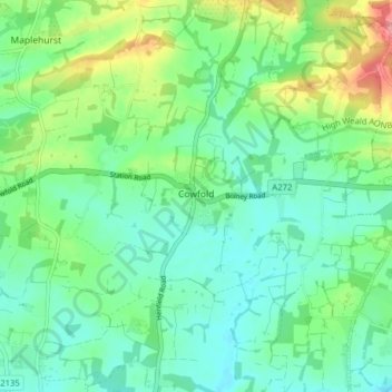
Name: Cowfold topographic map, elevation, terrain.
Location: Cowfold, Horsham, West Sussex, England, United Kingdom (50.96460 -0.30523 51.01414 -0.22957)
Average elevation: 32 m
Minimum elevation: 6 m
Maximum elevation: 97 m
Make a donation
Gear up for your next adventure:
As an Amazon Associate, this site earns from qualifying purchases at no extra cost to you.
Other topographic maps
Click on a map to view its topography, its elevation and its terrain.
Make a donation
Gear up for your next adventure:
As an Amazon Associate, this site earns from qualifying purchases at no extra cost to you.
Make a donation
Gear up for your next adventure:
As an Amazon Associate, this site earns from qualifying purchases at no extra cost to you.
Gay Street
United Kingdom > England > West Sussex > Horsham > West Chiltington
Average elevation: 38 m
Make a donation
Gear up for your next adventure:
As an Amazon Associate, this site earns from qualifying purchases at no extra cost to you.
Sullington Warren
United Kingdom > England > West Sussex > Horsham > Storrington
Average elevation: 54 m
Make a donation
Gear up for your next adventure:
As an Amazon Associate, this site earns from qualifying purchases at no extra cost to you.
Smock Alley
United Kingdom > England > West Sussex > Horsham > West Chiltington Common
Average elevation: 38 m
