Geolocate

Christleton topographic map

Click on the map to display elevation.

About this map

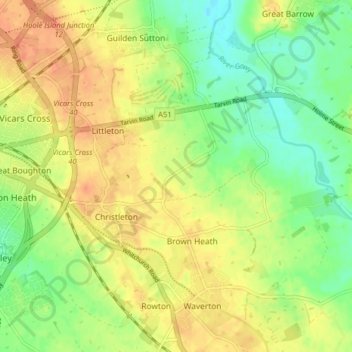
Name: Christleton topographic map, elevation, terrain.

Location: Christleton, Brown Heath, Cheshire West and Chester, England, United Kingdom (53.17396 -2.85749 53.20400 -2.77760)

Average elevation: 29 m

Minimum elevation: 7 m

Maximum elevation: 48 m

Other topographic maps

Click on a map to view its topography, its elevation and its terrain.

Gear up for your next adventure:

🗺️Topographic Maps - Detailed maps to explore trails, mountains, and wilderness areas
📷Outdoor Action Camera - Capture high-elevation views and rugged adventures
💧Hydration Bladder - Hands-free hydration solution for long treks
🩹Compact First Aid Kit - Pre-packed essentials for common trail injuries
🧴First Aid Kit - Essential first aid supplies for outdoor emergencies

As an Amazon Associate, this site earns from qualifying purchases at no extra cost to you.