
Flores topographic map
Interactive map
Click on the map to display elevation.
About this map
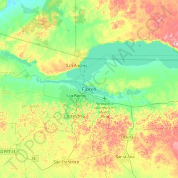
Name: Flores topographic map, elevation, terrain.
Location: Flores, Petén, 17002, Guatemala (16.76985 -90.05148 17.08985 -89.73148)
Average elevation: 189 m
Minimum elevation: 88 m
Maximum elevation: 373 m
Other topographic maps
Click on a map to view its topography, its elevation and its terrain.
Laguna Petenchel
Laguna Petenchel, Carretera a San Miguel, Zona 1, Santa Elena, Flores, Petén, 17001, Guatemala
Average elevation: 137 m