
Make a donation
Gear up for your next adventure:
As an Amazon Associate, this site earns from qualifying purchases at no extra cost to you.
Santander de Quilichao topographic map
Click on the map to display elevation.
Make a donation
Gear up for your next adventure:
As an Amazon Associate, this site earns from qualifying purchases at no extra cost to you.
About this map
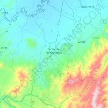
Name: Santander de Quilichao topographic map, elevation, terrain.
Location: Santander de Quilichao, Norte, Cauca, Colombia (2.84609 -76.61546 3.15049 -76.37358)
Average elevation: 1,337 m
Minimum elevation: 965 m
Maximum elevation: 2,752 m
Make a donation
Gear up for your next adventure:
As an Amazon Associate, this site earns from qualifying purchases at no extra cost to you.
Other topographic maps
Click on a map to view its topography, its elevation and its terrain.
Reserva Natural de la Sociedad Civil El Palmichal
Average elevation: 2,576 m
Make a donation
Gear up for your next adventure:
As an Amazon Associate, this site earns from qualifying purchases at no extra cost to you.
Make a donation
Gear up for your next adventure:
As an Amazon Associate, this site earns from qualifying purchases at no extra cost to you.