
Felpós topographic map
Interactive map
Click on the map to display elevation.
About this map
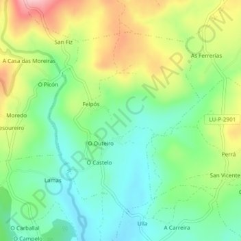
Name: Felpós topographic map, elevation, terrain.
Location: Felpós, Palas de Rei, Ulloa, Lugo, Galicia, España (42.91735 -7.89505 42.93726 -7.87194)
Average elevation: 510 m
Minimum elevation: 442 m
Maximum elevation: 622 m
Other topographic maps
Click on a map to view its topography, its elevation and its terrain.
Palas de Rei
Palas de Rei, Ulloa, Lugo, Galicia, 27200, España
Average elevation: 560 m