Geolocate

Orehovitsa topographic map

Click on the map to display elevation.

About this map

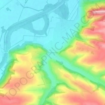
Name: Orehovitsa topographic map, elevation, terrain.

Location: Orehovitsa, Dolna Mitropolia, Pleven, Bulgaria (43.56768 24.36280 43.60768 24.40280)

Average elevation: 90 m

Minimum elevation: 31 m

Maximum elevation: 186 m

Other topographic maps

Click on a map to view its topography, its elevation and its terrain.

Nikopol

Bulgaria > Pleven

Average elevation: 95 m

Tatari

Bulgaria > Pleven

Average elevation: 74 m

Nikopol

Bulgaria > Pleven

Average elevation: 95 m

Gear up for your next adventure:

🧼Travel Hand Sanitizer - Keep hands clean when water is scarce
🚲Heavy Duty Bike Lock - Secure your bike at the trailhead or during stops
🦯Trekking Poles - Reduced impact on joints for steep topographic climbs
Backpacking Tent - Lightweight tent for long-distance hiking trips
🪜Heavy Duty Carabiners - Multi-use clips for securing gear to your backpack

As an Amazon Associate, this site earns from qualifying purchases at no extra cost to you.