Geolocate

Baucawe topographic map

Click on the map to display elevation.

About this map

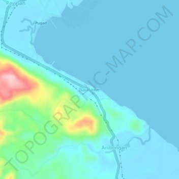
Name: Baucawe topographic map, elevation, terrain.

Location: Baucawe, Surigao del Sur, Caraga, 8307, Philippines (8.58138 126.07530 8.62138 126.11530)

Average elevation: 28 m

Minimum elevation: 0 m

Maximum elevation: 213 m

Other topographic maps

Click on a map to view its topography, its elevation and its terrain.

Bayabas

Philippines > Surigao del Sur

Average elevation: 35 m

Hinatuan

Philippines > Surigao del Sur

Average elevation: 30 m

Lingig

Philippines > Surigao del Sur

Average elevation: 70 m

Bislig

Philippines > Surigao del Sur

Average elevation: 71 m

Carac-an River

Philippines > Surigao del Sur > Cancavan

Average elevation: 23 m

Lingig

Philippines > Surigao del Sur

Average elevation: 70 m

Hinatuan

Philippines > Surigao del Sur

Average elevation: 30 m

Hinatuan

Philippines > Surigao del Sur

Average elevation: 30 m

Bislig

Philippines > Surigao del Sur

Average elevation: 71 m

Gear up for your next adventure:

🚲Heavy Duty Bike Lock - Secure your bike at the trailhead or during stops
🥾Hiking Shorts - Breathable shorts suitable for summer hikes
🎒Backpack Rain Cover - External shield to keep your entire pack dry
🧥Softshell Hiking Jacket - The perfect balance of wind protection and breathability
🏕️Camping Hammock - Integrated protection for sleeping between trees

As an Amazon Associate, this site earns from qualifying purchases at no extra cost to you.