Geolocate

Lanuza topographic map

Click on the map to display elevation.

About this map

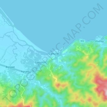
Name: Lanuza topographic map, elevation, terrain.

Location: Lanuza, Surigao del Sur, Caraga, Philippines (9.19368 126.02038 9.27368 126.10038)

Average elevation: 69 m

Minimum elevation: -2 m

Maximum elevation: 489 m

Gear up for your next adventure:

🔪Outdoor Multitool - Versatile tool for repairs and food prep in the wild
🧭GPS Tracker - Track your location in remote areas safely
🧦Hiking Liner Socks - Thin base layer to prevent friction and blisters
🔦LED Flashlight - Powerful and long-lasting flashlight for camping and emergencies
🥾Mountain Hiking Boots - High-traction boots for rocky terrain

As an Amazon Associate, this site earns from qualifying purchases at no extra cost to you.