
Cuenca topographic map
Click on the map to display elevation.
Cuenca
Cuenca, officially Santa Ana de los Ríos de Cuenca, is an Ecuadorian city, head of the canton of the same name and capital of the province of Azuay, as well as its largest and most populated city. It is crossed by the Tomebamba, Tarqui, Yanuncay and Machángara rivers, in the south-central inter-Andean region of Ecuador, in the Paute river basin, at an altitude of 2,538 meters above sea level and with a temperate Andean climate averaging 16.3 °C.
About this map
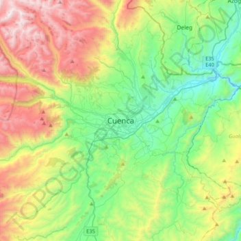
Name: Cuenca topographic map, elevation, terrain.
Location: Cuenca, Azuay, 010101, Ecuador (-3.05741 -79.16417 -2.73741 -78.84417)
Average elevation: 2,973 m
Minimum elevation: 2,311 m
Maximum elevation: 4,239 m
Other topographic maps
Click on a map to view its topography, its elevation and its terrain.
Parque Nacional Cajas
The highest point is the 4,450 m high Cerro Arquitectos (Architects Hill), and the elevation of roads reaches higher than 4,310 meters (13,550 feet). About 270 lakes and lagoons are present in the páramo of Cajas. Luspa is the largest of these lake and extends over 78 hectares with a maximum depth of 68 m at…
Average elevation: 3,767 m
Cuenca
Cuenca, officially Santa Ana de los Ríos de Cuenca, is an Ecuadorian city, head of the canton of the same name and capital of the province of Azuay, as well as its largest and most populated city. It is crossed by the Tomebamba, Tarqui, Yanuncay and Machángara rivers, in the south-central inter-Andean region…
Average elevation: 2,789 m
Tarqui
Coordinates: 3°00′49″S 79°02′04″W; Official Language: Spanish; Entity: Parish of Ecuador; Province: Azuay; Canton: Cuenca; President of the Parish Government: Galo Zhagüi; Subdivisions: 26 communities; Foundation and Parishization: October 18, 1915 (108 years old); Area: 135 km²; Average Altitude:…
Average elevation: 2,875 m
Cuenca
Cuenca, officially Santa Ana de los Ríos de Cuenca, is an Ecuadorian city, head of the canton of the same name and capital of the province of Azuay, as well as its largest and most populated city. It is crossed by the Tomebamba, Tarqui, Yanuncay and Machángara rivers, in the south-central inter-Andean region…
Average elevation: 2,789 m