
Cuenca topographic map
Click on the map to display elevation.
Cuenca
Cuenca, officially Santa Ana de los Ríos de Cuenca, is an Ecuadorian city, head of the canton of the same name and capital of the province of Azuay, as well as its largest and most populated city. It is crossed by the Tomebamba, Tarqui, Yanuncay and Machángara rivers, in the south-central inter-Andean region of Ecuador, in the Paute river basin, at an altitude of 2,538 meters above sea level and with a temperate Andean climate averaging 16.3 °C.
About this map
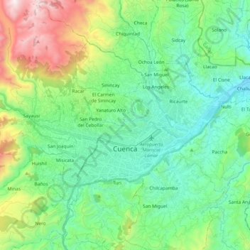
Name: Cuenca topographic map, elevation, terrain.
Location: Cuenca, Azuay, Ecuador (-2.93616 -79.07121 -2.82466 -78.88756)
Average elevation: 2,789 m
Minimum elevation: 2,361 m
Maximum elevation: 3,988 m