
Newsholme topographic map
Click on the map to display elevation.
About this map
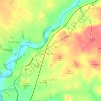
Name: Newsholme topographic map, elevation, terrain.
Location: Newsholme, Ribble Valley, Lancashire, England, United Kingdom (53.94685 -2.26949 53.97120 -2.22530)
Average elevation: 140 m
Minimum elevation: 98 m
Maximum elevation: 176 m
Other topographic maps
Click on a map to view its topography, its elevation and its terrain.
Billington and Langho
United Kingdom > England > Lancashire > Ribble Valley > Brockhall Village
Average elevation: 58 m
Old Langho
United Kingdom > England > Lancashire > Ribble Valley > Brockhall Village
Average elevation: 74 m
Brungerley Park
United Kingdom > England > Lancashire > Ribble Valley > Clitheroe > Waddington
Average elevation: 77 m
Mellor Brook
United Kingdom > England > Lancashire > Ribble Valley > Mellor Brook
Average elevation: 106 m