Geolocate

Sävsered topographic map

Click on the map to display elevation.

About this map

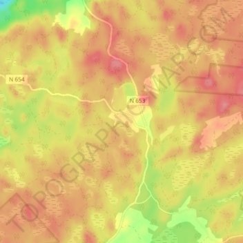
Name: Sävsered topographic map, elevation, terrain.

Location: Sävsered, Halmstads kommun, Halland County, Sweden (56.73473 13.24418 56.77473 13.28418)

Average elevation: 181 m

Minimum elevation: 129 m

Maximum elevation: 207 m

Other topographic maps

Click on a map to view its topography, its elevation and its terrain.

Hylte kommun

Sweden > Halland County

Average elevation: 145 m

Vendelsö

Sweden > Halland County

Average elevation: 2 m

Laholms kommun

Sweden > Halland County

Average elevation: 98 m

Gällarpesjön

Sweden > Halland County

Average elevation: 104 m

Halmstads kommun

Sweden > Halland County

Average elevation: 65 m

Bocksjö

Sweden > Halland County

Average elevation: 75 m

Kungsbacka kommun

Sweden > Halland County

Average elevation: 41 m

Tjolöholms slott

Sweden > Halland County

Average elevation: 3 m

Varbergs kommun

Sweden > Halland County

Average elevation: 35 m

Gear up for your next adventure:

🔦LED Headlamp - Hands-free lighting for early morning starts or late finishes
🧴Insect Repellent - Protect yourself from bugs during outdoor adventures
🚲Bike Repair Kit - Essential tools for on-trail mechanical issues
💧Reusable Water Bottle - Durable water bottles for hydration on trails
👖Convertible Hiking Pants - Zip-off legs to adapt to changing weather conditions

As an Amazon Associate, this site earns from qualifying purchases at no extra cost to you.