
Salfords topographic map
Click on the map to display elevation.
About this map
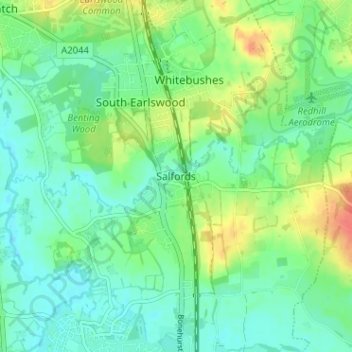
Name: Salfords topographic map, elevation, terrain.
Average elevation: 64 m
Minimum elevation: 49 m
Maximum elevation: 93 m
Other topographic maps
Click on a map to view its topography, its elevation and its terrain.
Horley
United Kingdom > England > Surrey > Reigate and Banstead
Horley is at an altitude of around 54 m (177 ft) above mean sea level.
Average elevation: 58 m
Lower Earlswood Lake
United Kingdom > England > Surrey > Reigate and Banstead > Redhill
Average elevation: 75 m
Redhill Common
United Kingdom > England > Surrey > Reigate and Banstead > Redhill
Average elevation: 92 m
Banstead Wood
United Kingdom > England > Surrey > Reigate and Banstead > Chipstead
Average elevation: 145 m
Reigate Park
United Kingdom > England > Surrey > Reigate and Banstead > Reigate
Average elevation: 80 m