Geolocate

Momil topographic map

Click on the map to display elevation.

About this map

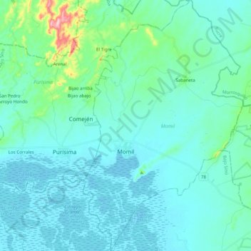
Name: Momil topographic map, elevation, terrain.

Location: Momil, Bajo Sínú, Córdoba, RAP Caribe, Colombia (9.16207 -75.70764 9.35316 -75.56281)

Average elevation: 29 m

Minimum elevation: -2 m

Maximum elevation: 230 m

Other topographic maps

Click on a map to view its topography, its elevation and its terrain.

Tierra Santa

Colombia > Córdoba > Buenavista

Average elevation: 31 m

La Ye

Colombia > Córdoba > Sahagún

Average elevation: 122 m

Gear up for your next adventure:

🧥Thermal Layer - Insulating layer for cold outdoor conditions
🧴Waterproofing Spray - Restore the DWR coating on jackets and tents
🥾Waterproof Trail Shoes - Shoes designed to handle wet terrain
🧥Ultralight Puffy Jacket - Maximum warmth that packs down to the size of an orange
🦟Insect Repellent - Keep mosquitoes and black flies away in wooded areas

As an Amazon Associate, this site earns from qualifying purchases at no extra cost to you.