
Village of the Hills topographic map
Interactive map
Click on the map to display elevation.
About this map
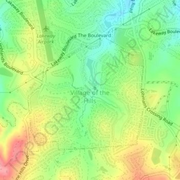
Name: Village of the Hills topographic map, elevation, terrain.
Location: Village of the Hills, Travis County, Texas, United States (30.33888 -97.99717 30.35692 -97.97684)
Average elevation: 276 m
Minimum elevation: 232 m
Maximum elevation: 332 m
Other topographic maps
Click on a map to view its topography, its elevation and its terrain.
Jonestown
United States > Texas > Travis County
Jonestown, Travis County, Texas, United States
Average elevation: 276 m
Austin
United States > Texas > Travis County
Austin, Travis County, Texas, United States
Average elevation: 216 m
Pflugerville
United States > Texas > Travis County > Pflugerville
Pflugerville, Travis County, Texas, United States
Average elevation: 215 m