Geolocate

Mounds View topographic map

Click on the map to display elevation.

About this map

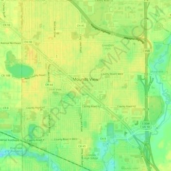
Name: Mounds View topographic map, elevation, terrain.

Location: Mounds View, Ramsey County, Minnesota, United States (45.08631 -93.22784 45.12455 -93.18732)

Average elevation: 276 m

Minimum elevation: 261 m

Maximum elevation: 284 m

Other topographic maps

Click on a map to view its topography, its elevation and its terrain.

Gladstone

United States > Minnesota > Ramsey County > Maplewood

Average elevation: 285 m

Midvale

United States > Minnesota > Ramsey County > Maplewood

Average elevation: 305 m

Como Lake

United States > Minnesota > Ramsey County > Saint Paul

Average elevation: 280 m

Gear up for your next adventure:

🧥Softshell Jacket - Windproof and breathable jacket for hiking
🦟Insect Repellent - Keep mosquitoes and black flies away in wooded areas
🛌Down Sleeping Bag - Superior warmth-to-weight ratio for cold nights
🪑Ultralight Camping Stool - Compact seating for rest stops during long hikes
💧Collapsible Water Bottle - Space-saving water bottle for outdoor activities

As an Amazon Associate, this site earns from qualifying purchases at no extra cost to you.