
lhad topographic map
Interactive map
Click on the map to display elevation.
About this map
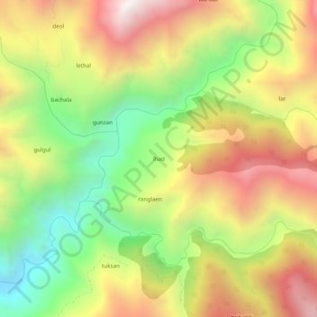
Name: lhad topographic map, elevation, terrain.
Location: lhad, Gool-Gulabgarh, Reasi district, Jammu-et-Cachemire, Inde (33.37807 74.89483 33.41807 74.93483)
Average elevation: 1,841 m
Minimum elevation: 1,185 m
Maximum elevation: 2,532 m
Other topographic maps
Click on a map to view its topography, its elevation and its terrain.
Gool-Gulabgarh
Inde > Jammu-et-Cachemire > Gool-Gulabgarh
Gool-Gulabgarh, Reasi district, Jammu-et-Cachemire, Inde
Average elevation: 2,190 m