
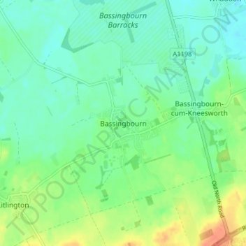
Bassingbourn topographic map
Click on the map to display elevation.
About this map
Name: Bassingbourn topographic map, elevation, terrain.
Average elevation: 31 m
Minimum elevation: 18 m
Maximum elevation: 58 m
Other topographic maps
Click on a map to view its topography, its elevation and its terrain.
West Wratting
United Kingdom > England > Cambridgeshire > South Cambridgeshire
Average elevation: 92 m
Great Abington
United Kingdom > England > Cambridgeshire > South Cambridgeshire
Average elevation: 55 m
Great Shelford
United Kingdom > England > Cambridgeshire > South Cambridgeshire
Average elevation: 22 m
West Wickham
United Kingdom > England > Cambridgeshire > South Cambridgeshire
Average elevation: 103 m
Papworth Everard
United Kingdom > England > Cambridgeshire > South Cambridgeshire
Average elevation: 51 m
Chittering
United Kingdom > England > Cambridgeshire > South Cambridgeshire > Waterbeach
Average elevation: 3 m
Great Eversden
United Kingdom > England > Cambridgeshire > South Cambridgeshire
Average elevation: 41 m
Little Abington
United Kingdom > England > Cambridgeshire > South Cambridgeshire
Average elevation: 46 m
Bassingbourn cum Kneesworth
United Kingdom > England > Cambridgeshire > South Cambridgeshire
Average elevation: 39 m
Little Shelford
United Kingdom > England > Cambridgeshire > South Cambridgeshire
Average elevation: 19 m
Castle Camps
United Kingdom > England > Cambridgeshire > South Cambridgeshire
Average elevation: 110 m
Weston Colville
United Kingdom > England > Cambridgeshire > South Cambridgeshire
Average elevation: 102 m
Guilden Morden
United Kingdom > England > Cambridgeshire > South Cambridgeshire
Average elevation: 50 m
Little Gransden
United Kingdom > England > Cambridgeshire > South Cambridgeshire
Average elevation: 68 m
Shingay cum Wendy
United Kingdom > England > Cambridgeshire > South Cambridgeshire > Wendy
Average elevation: 28 m
Nine Wells
United Kingdom > England > Cambridgeshire > South Cambridgeshire > Great Shelford
Average elevation: 20 m
Tadlow
United Kingdom > England > Cambridgeshire > South Cambridgeshire > Tadlow
Average elevation: 48 m
Shudy Camps
United Kingdom > England > Cambridgeshire > South Cambridgeshire > Shudy Camps
Average elevation: 104 m
Knapwell
United Kingdom > England > Cambridgeshire > South Cambridgeshire > Knapwell
Average elevation: 56 m
Gamlingay Wood NR
United Kingdom > England > Cambridgeshire > South Cambridgeshire > Gamlingay
Average elevation: 56 m
Hayley Wood NR
United Kingdom > England > Cambridgeshire > South Cambridgeshire > Hatley
Average elevation: 76 m
Little Eversden
United Kingdom > England > Cambridgeshire > South Cambridgeshire
Average elevation: 35 m