
Urcos topographic map
Click on the map to display elevation.
Urcos
The Urcos District is one of the twelve districts in the Quispicanchi Province in Peru. Created on January 2, 1857, its capital is the town of Urcos. Urcos is southeast of the former Inca capital, Cusco, in the southern Andes, and it is at an altitude of 3,180 meters (10,430 ft).
About this map
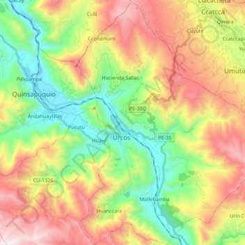
Name: Urcos topographic map, elevation, terrain.
Location: Urcos, Province of Quispicanchis, Cusco, Peru (-13.75910 -71.65575 -13.59748 -71.52464)
Average elevation: 3,731 m
Minimum elevation: 3,066 m
Maximum elevation: 4,644 m
Other topographic maps
Click on a map to view its topography, its elevation and its terrain.
Ausangate
Ausangate or Auzangate (in Hispanicized spellings) is a mountain of the Vilcanota mountain range in the Andes of Peru. With an elevation of 6,384 metres, it is situated around 100 kilometres southeast of Cusco in the Cusco Region, Canchis Province, Pitumarca District, and in the Quispicanchi Province, Ocongate…
Average elevation: 5,617 m