Geolocate

Ausangate topographic map

Click on the map to display elevation.

Ausangate

Ausangate or Auzangate (in Hispanicized spellings) is a mountain of the Vilcanota mountain range in the Andes of Peru. With an elevation of 6,384 metres, it is situated around 100 kilometres southeast of Cusco in the Cusco Region, Canchis Province, Pitumarca District, and in the Quispicanchi Province, Ocongate District.

About this map

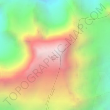
Name: Ausangate topographic map, elevation, terrain.

Location: Ausangate, Ocongate, Province of Quispicanchis, Cusco, Peru (-13.78912 -71.22995 -13.78902 -71.22985)

Average elevation: 5,617 m

Minimum elevation: 4,874 m

Maximum elevation: 6,359 m

Gear up for your next adventure:

Camping Essentials - All-in-one gear for a comfortable camping trip
🥾Mountain Hiking Shoes - Shoes with superior grip for mountainous terrain
🧤Rechargeable Heated Gloves - Extreme warmth for Canadian winter expeditions
🔨Vehicle Emergency Tool - Safety tool for remote road trips to trailheads
🧢Beanie Hat - Keep your head warm in cold weather

As an Amazon Associate, this site earns from qualifying purchases at no extra cost to you.