
Make a donation
Gear up for your next adventure:
As an Amazon Associate, this site earns from qualifying purchases at no extra cost to you.
Priboj Municipality topographic map
Click on the map to display elevation.
Make a donation
Gear up for your next adventure:
As an Amazon Associate, this site earns from qualifying purchases at no extra cost to you.
About this map
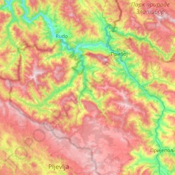
Name: Priboj Municipality topographic map, elevation, terrain.
Average elevation: 888 m
Minimum elevation: 334 m
Maximum elevation: 1,485 m
Make a donation
Gear up for your next adventure:
As an Amazon Associate, this site earns from qualifying purchases at no extra cost to you.
Other topographic maps
Click on a map to view its topography, its elevation and its terrain.
Mali Povlen
Serbia > Zlatibor Administrative District > Kosjeric Municipality
Average elevation: 1,139 m
Валеница
Serbia > Zlatibor Administrative District > Prijepolje Municipality
Average elevation: 1,474 m
Валеница
Serbia > Zlatibor Administrative District > Prijepolje Municipality
Average elevation: 1,474 m
Make a donation
Gear up for your next adventure:
As an Amazon Associate, this site earns from qualifying purchases at no extra cost to you.