Geolocate

3rd district topographic map

Click on the map to display elevation.

About this map

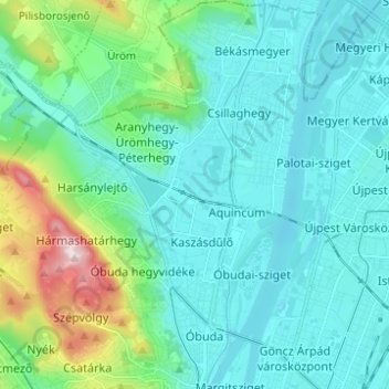
Name: 3rd district topographic map, elevation, terrain.

Location: 3rd district, Budapest, Central Hungary, Hungary (47.52679 18.97684 47.61010 19.07672)

Average elevation: 164 m

Minimum elevation: 94 m

Maximum elevation: 489 m

Other topographic maps

Click on a map to view its topography, its elevation and its terrain.

Danube

Hungary > Budapest

Average elevation: 114 m

Kis-Sváb-hegy

Hungary > Budapest

Average elevation: 195 m

Gellért Hill

Hungary > Budapest

Average elevation: 126 m

Ziggurat

Hungary > Budapest

Average elevation: 108 m

Csúcs-hegy

Hungary > Budapest

Average elevation: 261 m

Gellért Hill

Hungary > Budapest

Average elevation: 126 m

Tigers

Hungary > Budapest

Average elevation: 111 m

Danube

Hungary > Budapest

Average elevation: 125 m

Gear up for your next adventure:

🧢Outdoor Visor - Breathable visor for sunny hikes
Bushcraft Tarp - Versatile emergency shelter or gear protection
🎒Hiking Backpack - Lightweight and ergonomic backpacks for day hikes or multi-day treks
🧢Hiking Hat - Sun-protective and breathable hats for long treks
🦶Hiking Shoe Insoles - Added support for high arches and long days on feet

As an Amazon Associate, this site earns from qualifying purchases at no extra cost to you.