
Stacksteads topographic map
Click on the map to display elevation.
About this map
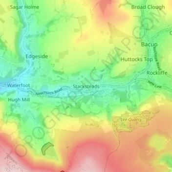
Name: Stacksteads topographic map, elevation, terrain.
Average elevation: 306 m
Minimum elevation: 188 m
Maximum elevation: 464 m
Other topographic maps
Click on a map to view its topography, its elevation and its terrain.
Clowbridge
United Kingdom > England > Lancashire > Borough of Rossendale > Habergham Eaves
Average elevation: 319 m
Cowm Reservoir
United Kingdom > England > Lancashire > Borough of Rossendale > Whitworth > Shawforth
Average elevation: 302 m