Geolocate

Alba topographic map

Click on the map to display elevation.

About this map
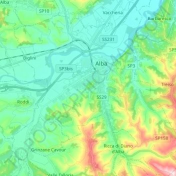
Name: Alba topographic map, elevation, terrain.

Location: Alba, Cuneo, Piedmont, Italy (44.63797 7.96642 44.73451 8.09854)

Average elevation: 255 m

Minimum elevation: 140 m

Maximum elevation: 584 m

Other topographic maps

Click on a map to view its topography, its elevation and its terrain.

Viozene

Italy > Piedmont > Cuneo > Ormea

Average elevation: 1,542 m

Ciampetti

Italy > Piedmont > Cuneo > Ostana

Average elevation: 1,318 m

Gear up for your next adventure:

🧥Softshell Hiking Jacket - The perfect balance of wind protection and breathability
🧣Merino Neck Gaiter - Protects against wind, sun, and cold at high altitudes
🎒Fully Waterproof Backpack - Total protection for photography gear and electronics
🛶Canoe Life Vest - Safety vest for water sports
🥾Waterproof Hiking Shoes - Durable shoes for wet and rugged trails

As an Amazon Associate, this site earns from qualifying purchases at no extra cost to you.