
Make a donation
Gear up for your next adventure:
As an Amazon Associate, this site earns from qualifying purchases at no extra cost to you.
Area E (Elphinstone) topographic map
Click on the map to display elevation.
Make a donation
Gear up for your next adventure:
As an Amazon Associate, this site earns from qualifying purchases at no extra cost to you.
About this map
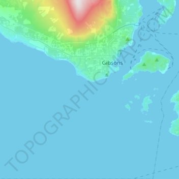
Name: Area E (Elphinstone) topographic map, elevation, terrain.
Average elevation: 77 m
Minimum elevation: -1 m
Maximum elevation: 1,164 m
Sunshine Coast Regional District trails, hiking, mountain biking, running and outdoor activities
Make a donation
Gear up for your next adventure:
As an Amazon Associate, this site earns from qualifying purchases at no extra cost to you.
Other topographic maps
Click on a map to view its topography, its elevation and its terrain.
Roberts Creek
Canada > British Columbia > Sunshine Coast Regional District > Area D (Roberts Creek)
Average elevation: 56 m
Secret Cove
Canada > British Columbia > Sunshine Coast Regional District > Area B (Halfmoon Bay)
Average elevation: 88 m
Halfmoon Bay
Canada > British Columbia > Sunshine Coast Regional District > Area B (Halfmoon Bay)
Average elevation: 102 m
Earls Cove
Canada > British Columbia > Sunshine Coast Regional District > Area A (Egmont/Pender Harbour)
Average elevation: 84 m
Make a donation
Gear up for your next adventure:
As an Amazon Associate, this site earns from qualifying purchases at no extra cost to you.
Irvine Lake
Canada > British Columbia > Sunshine Coast Regional District > Area B (Halfmoon Bay)
Average elevation: 673 m
Langdale
Canada > British Columbia > Sunshine Coast Regional District > Area F (West Howe Sound)
Average elevation: 55 m
Pender Hill
Canada > British Columbia > Sunshine Coast Regional District > Area A (Egmont/Pender Harbour)
Average elevation: 48 m
Mount Alice
Canada > British Columbia > Sunshine Coast Regional District > Area A (Egmont/Pender Harbour)
Average elevation: 1,264 m
Make a donation
Gear up for your next adventure:
As an Amazon Associate, this site earns from qualifying purchases at no extra cost to you.
Mount Albert
Canada > British Columbia > Sunshine Coast Regional District > Area A (Egmont/Pender Harbour)
Average elevation: 1,937 m
Mount Churchill
Canada > British Columbia > Sunshine Coast Regional District > Area A (Egmont/Pender Harbour)
Average elevation: 1,150 m
Mount Helena
Canada > British Columbia > Sunshine Coast Regional District > Area A (Egmont/Pender Harbour)
Average elevation: 1,061 m
Chapman Lake
Canada > British Columbia > Sunshine Coast Regional District > Area D (Roberts Creek)
Average elevation: 1,111 m
Make a donation
Gear up for your next adventure:
As an Amazon Associate, this site earns from qualifying purchases at no extra cost to you.
Gower Point
Canada > British Columbia > Sunshine Coast Regional District > Area E (Elphinstone)
Average elevation: 33 m
Macdonald Island
Canada > British Columbia > Sunshine Coast Regional District > Area A (Egmont/Pender Harbour)
Average elevation: 230 m
Highest Peak
Canada > British Columbia > Sunshine Coast Regional District > Area F (West Howe Sound) > Plumper Cove
Average elevation: 42 m
Mount Helena
Canada > British Columbia > Sunshine Coast Regional District > Area A (Egmont/Pender Harbour)
Average elevation: 1,061 m
Make a donation
Gear up for your next adventure:
As an Amazon Associate, this site earns from qualifying purchases at no extra cost to you.
Langdale
Canada > British Columbia > Sunshine Coast Regional District > Area F (West Howe Sound)
Average elevation: 55 m