Geolocate

Hallam Moors topographic map

Click on the map to display elevation.

About this map

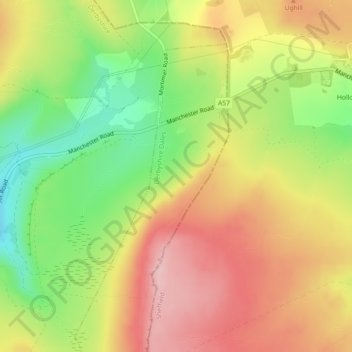
Name: Hallam Moors topographic map, elevation, terrain.

Location: Hallam Moors, Hathersage, Derbyshire Dales, Derbyshire, England, S6 6GL, United Kingdom (53.37173 -1.67023 53.39173 -1.65023)

Average elevation: 368 m

Minimum elevation: 273 m

Maximum elevation: 452 m

Other topographic maps

Click on a map to view its topography, its elevation and its terrain.

Gear up for your next adventure:

🥾Hiking Boots - Sturdy boots providing ankle support and traction on rugged trails
🚲Heavy Duty Bike Lock - Secure your bike at the trailhead or during stops
Camping Groundsheet - Protect your tent from moisture and dirt
🧴First Aid Kit - Essential first aid supplies for outdoor emergencies
🧊Portable Cooler - Keep food and drinks cold during outdoor adventures

As an Amazon Associate, this site earns from qualifying purchases at no extra cost to you.