
Make a donation
Gear up for your next adventure:
As an Amazon Associate, this site earns from qualifying purchases at no extra cost to you.
Valley Mills topographic map
Click on the map to display elevation.
Make a donation
Gear up for your next adventure:
As an Amazon Associate, this site earns from qualifying purchases at no extra cost to you.
Valley Mills
The airport covers 90 acres (36 ha) at an elevation of 751 feet (229 m) above mean sea level (AMSL), and has two runways.
Make a donation
Gear up for your next adventure:
As an Amazon Associate, this site earns from qualifying purchases at no extra cost to you.
About this map
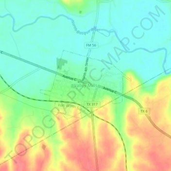
Name: Valley Mills topographic map, elevation, terrain.
Location: Valley Mills, Bosque County, Texas, United States (31.64640 -97.48992 31.67033 -97.44860)
Average elevation: 191 m
Minimum elevation: 164 m
Maximum elevation: 230 m
Make a donation
Gear up for your next adventure:
As an Amazon Associate, this site earns from qualifying purchases at no extra cost to you.
Other topographic maps
Click on a map to view its topography, its elevation and its terrain.
Make a donation
Gear up for your next adventure:
As an Amazon Associate, this site earns from qualifying purchases at no extra cost to you.