Geolocate

Eachome topographic map

Click on the map to display elevation.

About this map

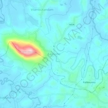
Name: Eachome topographic map, elevation, terrain.

Location: Eachome, Mananthavady, Wayanad, Kerala, 673124, India (11.67535 76.02284 11.71535 76.06284)

Average elevation: 749 m

Minimum elevation: 717 m

Maximum elevation: 992 m

Other topographic maps

Click on a map to view its topography, its elevation and its terrain.

Mazhuvannoor

India > Kerala > Mananthavady > Mazhuvannur

Average elevation: 733 m

Vellamunda

India > Kerala > Mananthavady > Peechamcode

Average elevation: 812 m

Kattikulam

India > Kerala > Mananthavady > Kattikkulam

Average elevation: 772 m

Gear up for your next adventure:

🛁Quick-Dry Microfiber Towel - Space-saving towel that dries rapidly on the move
🔨Vehicle Emergency Tool - Safety tool for remote road trips to trailheads
💡LED Headlamp - Hands-free illumination for night hiking and camping
🧊Portable Cooler - Keep food and drinks cold during outdoor adventures
🚑Survival Whistle - Signal for help across long distances in mountains

As an Amazon Associate, this site earns from qualifying purchases at no extra cost to you.