Geolocate

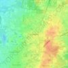
Losser topographic map

Click on the map to display elevation.

About this map
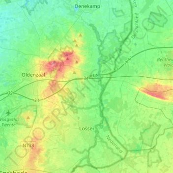
Name: Losser topographic map, elevation, terrain.

Location: Losser, Overijssel, Netherlands (52.22074 6.93433 52.37986 7.07276)

Average elevation: 37 m

Minimum elevation: 17 m

Maximum elevation: 85 m

Other topographic maps

Click on a map to view its topography, its elevation and its terrain.

De Meele

Netherlands > Overijssel > Nieuwleusen

Average elevation: 2 m

Lonneker

Netherlands > Overijssel > Enschede

Average elevation: 47 m

Schoolbuurt

Netherlands > Overijssel > Markelo

Average elevation: 17 m

Enschede

Netherlands > Overijssel > Enschede

Average elevation: 34 m

Lemelerberg

Netherlands > Overijssel > Lemele

Average elevation: 19 m

Frankhuis

Netherlands > Overijssel > Zwolle

Average elevation: 3 m

Usselo

Netherlands > Overijssel > Enschede

Average elevation: 31 m

Tankenberg

Netherlands > Overijssel > de Lutte

Average elevation: 58 m

Zuurberg

Netherlands > Overijssel > Holten

Average elevation: 17 m

Helhuizen

Netherlands > Overijssel > Holten

Average elevation: 20 m

Witteberg

Netherlands > Overijssel

Average elevation: 57 m

Gear up for your next adventure:

🥾Waterproof Hiking Shoes - Durable shoes for wet and rugged trails
🧭GPS Handheld Device - Reliable GPS navigation for outdoor adventures
🧰Emergency Multi-Tool - Compact multi-tool for outdoor survival
🛌Insulated Sleeping Pad - Critical thermal barrier between you and the cold ground
🛁Quick-Dry Microfiber Towel - Space-saving towel that dries rapidly on the move

As an Amazon Associate, this site earns from qualifying purchases at no extra cost to you.